M5Stack Mini GPS/BDS Unit (AT6558) (Grove)
File:TArduino M5Stack Mini GPS AT6558.png
Summary
This component interfaces with the **M5Stack Mini GPS/BDS Unit (AT6558)** via a Grove UART connection. It provides comprehensive navigation and positioning data including latitude, longitude, altitude, speed, and satellite status.
Description
The **M5Stack Mini GPS/BDS Unit (AT6558)** uses the AT6558 GNSS chip to support both GPS and BDS constellations. It communicates over a Grove-compatible UART interface, outputting NMEA sentences containing navigation data. The component parses this data to extract useful information such as position, course, UTC time, and detailed satellite status.
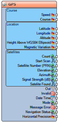
Diagram:
Properties
- Enabled – Enables or disables the component.
- Base Year – Sets the base year (e.g., 2000) for correct date interpretation.
Pins
Output Pins
Course
- Speed – Current ground speed (analog).
- Course – Current heading or direction of travel (analog).
Location
- Latitude – Latitude in degrees (analog).
- Longitude – Longitude in degrees (analog).
- Altitude – Altitude above sea level (analog).
- Height Above WGS84 Ellipsoid – Height relative to WGS84 ellipsoid (analog).
- Magnetic Variation – Magnetic variation in degrees (analog).
Satellites
- Count – Number of satellites in view (unsigned).
- Start Scan – Clock input to initiate satellite scanning.
- Satellite Number (PRN) – Satellite ID (unsigned).
- Elevation – Elevation angle of the satellite (analog).
- Azimuth – Azimuth angle of the satellite (analog).
- Signal Strength (dB) – Signal-to-noise ratio of satellite (analog).
- Satellite Found – Digital signal indicating satellite presence.
General Outputs
- Out – Serial text output with raw NMEA sentences.
- Date/Time – UTC date and time.
- Invalid – High if the received data is invalid (digital).
- Message Error – High if a parsing error occurs (digital).
- Mode – Current fix mode (unsigned).
- Navigation Status – Textual navigation status.
- Horizontal Precision – Horizontal dilution of precision (HDOP, analog).
Categories
- File:TArduinoSensorsCategory.png Category Sensors – Components for interfacing with sensors.
- File:TArduinoCommunicationsCategory.png Category Communications – Components for data communication.
- File:TArduinoGPSCategory.png Category GPS – GPS/GNSS positioning components.
