U-Blox M8 GPS (Serial): Difference between revisions
Jump to navigation
Jump to search
Created page with "Image:TArduino_UBlox_M8_GPS_Serial.png == Summary == This component interfaces with a U-Blox M8 GPS module using a serial (UART) connection. It processes raw satellite data to provide comprehensive navigation information. == Description == The U-Blox M8 GPS (Serial) component reads data from the GPS module via a serial port. It is designed to parse standard NMEA sentences or proprietary UBX messages to extract useful information. This includes geographical location..." |
No edit summary |
||
| Line 5: | Line 5: | ||
== Description == | == Description == | ||
The U-Blox M8 GPS (Serial) component reads data from the GPS module via a serial port. It | The **U-Blox M8 GPS (Serial)** component reads data from the GPS module via a serial port. | ||
It parses NMEA sentences or UBX messages to extract useful information including geographical location, precise time, speed, altitude, and detailed satellite data. | |||
<b>Diagram:</b> | |||
[[Image:TArduino_UBlox_M8_GPS_Serial.Preview.png]] | [[Image:TArduino_UBlox_M8_GPS_Serial.Preview.png]] | ||
| Line 18: | Line 18: | ||
== Pins == | == Pins == | ||
=== Input Pins === | === Input Pins === | ||
*'''Reset (clock)''' – A clock signal on this pin resets the component. | |||
*'''Reset (clock)''' – A clock signal on this pin | |||
=== Output Pins === | === Output Pins === | ||
*'''Location''' – Outputs | ==== Course ==== | ||
*'''Date/Time''' – | *'''Speed''' – Current ground speed (analog). | ||
*''' | *'''Course''' – Current heading or direction of travel (analog). | ||
*''' | |||
*''' | ==== Location ==== | ||
*''' | *'''Latitude''' – Latitude in degrees (analog). | ||
*''' | *'''Longitude''' – Longitude in degrees (analog). | ||
*'''Altitude''' – Altitude above sea level (analog). | |||
*'''Height Above WGS84 Ellipsoid''' – Height relative to WGS84 ellipsoid (analog). | |||
*'''Magnetic Variation''' – Magnetic variation in degrees (analog). | |||
==== Satellites ==== | |||
*'''Count''' – Number of satellites in view (unsigned). | |||
*'''Start Scan''' – Clock input to initiate satellite scanning. | |||
*'''Satellite Number (PRN)''' – Satellite ID (unsigned). | |||
*'''Elevation''' – Elevation angle of the satellite (analog). | |||
*'''Azimuth''' – Azimuth angle of the satellite (analog). | |||
*'''Signal Strength (dB)''' – Signal-to-noise ratio of satellite (analog). | |||
*'''Satellite Found''' – Digital signal indicating satellite presence. | |||
==== General Outputs ==== | |||
*'''Out''' – Raw NMEA/UBX data output (text). | |||
*'''Date/Time''' – UTC date and time. | |||
*'''Invalid''' – High if the received data is invalid (digital). | |||
*'''Message Error''' – High if a parsing error occurs (digital). | |||
*'''Reset''' – Indicates a reset operation (clock). | |||
*'''Mode''' – Current fix mode (unsigned). | |||
*'''Navigation Status''' – Textual navigation status. | |||
*'''Horizontal Precision''' – Horizontal dilution of precision (HDOP, analog). | |||
== Categories == | == Categories == | ||
*[[Image:TArduinoSensorsCategory.png]] [[Category | *[[Image:TArduinoSensorsCategory.png]] [[Category Sensors]] – Components for interfacing with sensors. | ||
*[[Image:TArduinoCommunicationsCategory.png]] [[Category | *[[Image:TArduinoCommunicationsCategory.png]] [[Category Communications]] – Components for data communication. | ||
[[Category:Components]] | [[Category:Components]] | ||
Latest revision as of 13:06, 15 September 2025
File:TArduino UBlox M8 GPS Serial.png
Summary
This component interfaces with a U-Blox M8 GPS module using a serial (UART) connection. It processes raw satellite data to provide comprehensive navigation information.
Description
The **U-Blox M8 GPS (Serial)** component reads data from the GPS module via a serial port. It parses NMEA sentences or UBX messages to extract useful information including geographical location, precise time, speed, altitude, and detailed satellite data.
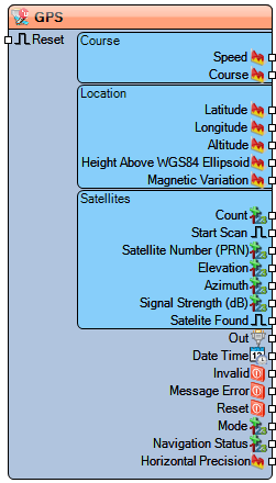
Diagram:
Properties
- Enabled – Enables or disables the component.
- Base Year – Sets the base year (e.g., 2000) for correct date interpretation.
Pins
Input Pins
- Reset (clock) – A clock signal on this pin resets the component.
Output Pins
Course
- Speed – Current ground speed (analog).
- Course – Current heading or direction of travel (analog).
Location
- Latitude – Latitude in degrees (analog).
- Longitude – Longitude in degrees (analog).
- Altitude – Altitude above sea level (analog).
- Height Above WGS84 Ellipsoid – Height relative to WGS84 ellipsoid (analog).
- Magnetic Variation – Magnetic variation in degrees (analog).
Satellites
- Count – Number of satellites in view (unsigned).
- Start Scan – Clock input to initiate satellite scanning.
- Satellite Number (PRN) – Satellite ID (unsigned).
- Elevation – Elevation angle of the satellite (analog).
- Azimuth – Azimuth angle of the satellite (analog).
- Signal Strength (dB) – Signal-to-noise ratio of satellite (analog).
- Satellite Found – Digital signal indicating satellite presence.
General Outputs
- Out – Raw NMEA/UBX data output (text).
- Date/Time – UTC date and time.
- Invalid – High if the received data is invalid (digital).
- Message Error – High if a parsing error occurs (digital).
- Reset – Indicates a reset operation (clock).
- Mode – Current fix mode (unsigned).
- Navigation Status – Textual navigation status.
- Horizontal Precision – Horizontal dilution of precision (HDOP, analog).
Categories
- File:TArduinoSensorsCategory.png Category Sensors – Components for interfacing with sensors.
- File:TArduinoCommunicationsCategory.png Category Communications – Components for data communication.
